Maps are Us (January 1-7, 2017)

Diego Gutierrez, The Americas, c. 1562 (Click on the map to see the full-sized image at the British Library)
In 1562, Diego Gutierrez and Hieronymus Cock created a map of the Spanish Empire for King Phillip II. Gutierrez was a cartographer and cosmographer for the Casa de Contración (a government agency tasked with trying to control Spanish exploration and settlement); Cock was a master etcher and painter in Antwerp, which was then part of the Spanish Netherlands. Cock is also credited with shifting etching and printmaking from a strictly individual endeavor to an industrial approach that relied on a division of labor.

Sea monster in the Atlantic. Image from Library of Congress, 1562 Map of America.
The map, titled Americae Sive Quartae Orbis Partis Nova Et Exactissima Descriptio,” in notable in a number of ways: it was the first to name California and Appalachia (Apalchen); it depicted, rather accurately, a wide range of geographic features, including the Amazon watershed; and functions not only as a map but also as a work of art, most notably because of the embellishments, including monkeys, sea monsters, cannibals, giants, and Phillip II portrayed as Neptune.
The map was meant to describe and delineate the reach of the Spanish Empire, claiming much of the territory in both North and South America as part of the Spanish Empire…ignoring, of course, the claims of prior inhabitants. While the were useful in terms of navigation and understanding of geography, they were (and still remain) a propaganda tool designed to underscore the power of the Iberian peninsula (i.e. Spain, Portugal, and, by marriage, France). As the Library of Congress notes “it is apparent that one of the intentions of preparing the map was to define clearly Spain’s America for the other European powers who might have designs on the region.” Only two copies of this map are known to exist: one resides in the British Library and the other is in the map collection of U.S. Library of Congress in Washington D.C.
Table of Contents
Did You Know?…
The Library of Congress has the largest map collection in the world. According to their website, their collection includes “5.5 million maps, 80,000 atlases, 600 reference works, 500+ globes, 3,000 raised relief models, and a large number of cartographic materials, including over 19,000 cds/dvds.” To see all of them, you have to go to Washington D.C., but a fairly good collection (albeit a drop in the bucket) exists online.
Projects & Activities:
1. Create a Memory Map
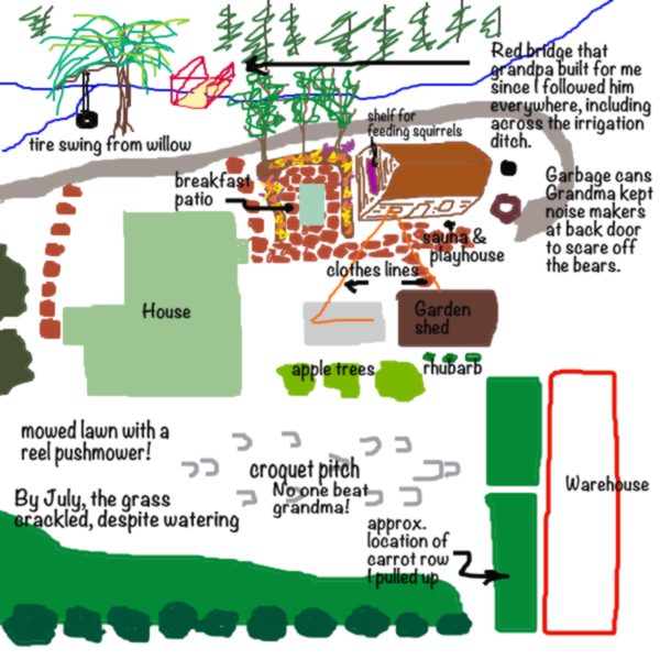
A memory map is used to capture and record memories relative to local geography. It is a hand-drawn map of a place you are fond of or for which you have strong memories. It might be your grandparent’s farm or your parent’s neighborhood or your school. Unlike regular maps that provide geographic information (roads, place names, geographic features like streams or mountains, etc.), memory maps also include information (stories and comments) and embellishments (illustrations) not typically found on your average map. We’ve provided an example of a memory map below:

Start by drawing a rough map in pencil and then start filling in the detail. Write notes on your map to indicate those areas that trigger strong memories. In the example above, I included the croquet pitch–my grandmother was a demon croquet player who rarely lost and, while generally a very nice person, took inordinate pleasure in sending other folks balls in the opposite direction of where they needed to go. There was a red and white bridge spanning the irrigation ditch that ran along the north side of the house (actually, I think it was, in reality, the west side…but I was somewhat directionally challenged as a child). My grandfather built the bridge since I tried to follow him everywhere, including across the plank they had used to cross the ditch for years.
2. Make a map using a GIS (Geographic Information System) program.
There are a number of online mapping programs, from Google to Grass. One of our favorites, however, is Scribble Maps. It is a free mapping program (basic service) that allows students and teachers play with geography. The site includes some excellent examples. While there are some tutorials, this is really the type of site where you just play.
Map Resources:
Magnificent Maps: Power, Propaganda, and Art. Exhibition at the British Library, 2010.
Maps. The British Library. One of the best map collections and collections of map resources (articles, videos, et alia).
The 1562 Map of America by Diego Gutiérrez, Library of Congress. Excellent discussion of the Gutiérrez & Cock map.
Map Collections. Library of Congress. An excellent resource for all sorts of historical maps…railroad maps, national park maps, Civil War maps, WWII Military Situation Maps, the Sanborn Insurance maps, and many others.
Map Videos:
Maps are especially useful in bringing history to life…whether it is looking at changes in Europe over time or looking at the routing of the Blue Ridge Parkway.
After you watch the above video, take a look at the Driving Through Time site developed by the University of North Carolina.
In both cases, the maps are communicating an idea rather than just providing travel information.
Geography @ the Cambria Toy Station
Check out some of the great geography products we have at the Cambria Toy Station:


Comments
Maps are Us (January 1-7, 2017) — No Comments
HTML tags allowed in your comment: <a href="" title=""> <abbr title=""> <acronym title=""> <b> <blockquote cite=""> <cite> <code> <del datetime=""> <em> <i> <q cite=""> <s> <strike> <strong>